Back Kabupatén Tegal BAN Tegal Kabupatèn BEW Kabupaten Tegal CEB Tegal (Regierungsbezirk) German Kabupaten de Tegal French Kabupaten Tegal ID Reggenza di Tegal Italian Kabupatèn Tegal JV Kabupaten Tegal MAP-BMS Tegal (regentschap) Dutch
Tegal Regency
Kabupaten Tegal | |
|---|---|
| Other transcription(s) | |
| • Javanese | ꦏꦧꦸꦥꦠꦺꦤ꧀ꦠꦺꦒꦭ꧀ |
 Guci forest park | |
| Nickname: Tegal Hadiningrat | |
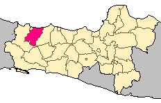
 Location within Central Java | |
| Coordinates: 06°57′56″S 109°10′45″E / 6.96556°S 109.17917°E | |
| Country | |
| Province | |
| Settled | May 18, 1601 |
| Founded by | Ki Gede Sebayu |
| Named after | Teteguall Land |
| Capital | Slawi |
| Government | |
| • Body | Tegal Regency Government |
| • Regent | Ischak Maulana Rohman |
| • Vice Regent | Ahmad Kholid |
| Area | |
• Total | 983.9 km2 (379.9 sq mi) |
| • Rank | 21st in Central Java |
| Population (mid 2024 estimate) | |
• Total | 1,674,803 |
| • Rank | [1] |
| • Density | 1,700/km2 (4,400/sq mi) |
| Demonym | Tegalese |
| Demographics | |
| • Ethnic groups | Javanese (98%) Chinese (2%) |
| • Languages | Tegalese Javanese Indonesian |
| Time zone | UTC+7 (Indonesia Western Time) |
| Area code | (+62) 283 |
| ISO 3166 code | ID-SLW |
| Vehicle registration | G |
| Largest district by area | Jatinegara - 109.5 square kilometres (42.3 sq mi) |
| Largest district by population | Adiwerna - (134,556 in mid 2024) |
| Districts | 18 |
| - Rural Villages - Urban Villages | 281 6 |
| Website | tegalkab |
Tegal Regency (Javanese:ꦏꦧꦸꦥꦠꦺꦤ꧀ꦠꦺꦒꦭ꧀) is one of the regencies (kabupaten) in the northwest corner of Central Java province of Indonesia, with an area of 983.9 km2 (379.9 sq mi). The regency's administrative center used to be in Tegal City, in the northwest corner of the regency, but then Tegal City was administratively separated from the regency and formed into its own territory. The city was later replaced as the administrative center of Tegal Regency by Slawi Town, which is a suburb about 20 km (12 mi) to the south of the city and within the district boundary. The regency had a population of 1,394,839 at the 2010 Census[2] and 1,596,996 at the 2020 Census;[3] the official estimate as at mid 2024 was 1,674,803 (comprising 848,602 males and 826,201 females).[1]


